
Make a donation
Gear up for your next adventure:
As an Amazon Associate, this site earns from qualifying purchases at no extra cost to you.
Bleasby topographic map
Click on the map to display elevation.
Make a donation
Gear up for your next adventure:
As an Amazon Associate, this site earns from qualifying purchases at no extra cost to you.
About this map
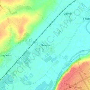
Name: Bleasby topographic map, elevation, terrain.
Average elevation: 28 m
Minimum elevation: 10 m
Maximum elevation: 77 m
Nottinghamshire trails, hiking, mountain biking, running and outdoor activities
Make a donation
Gear up for your next adventure:
As an Amazon Associate, this site earns from qualifying purchases at no extra cost to you.
Other topographic maps
Click on a map to view its topography, its elevation and its terrain.
Sherwood Forest NNR
United Kingdom > England > Nottinghamshire > Newark and Sherwood > Ollerton > Edwinstowe CP
Average elevation: 71 m
Make a donation
Gear up for your next adventure:
As an Amazon Associate, this site earns from qualifying purchases at no extra cost to you.
Make a donation
Gear up for your next adventure:
As an Amazon Associate, this site earns from qualifying purchases at no extra cost to you.
Balderton
United Kingdom > England > Nottinghamshire > Newark and Sherwood > Balderton
Average elevation: 20 m
Make a donation
Gear up for your next adventure:
As an Amazon Associate, this site earns from qualifying purchases at no extra cost to you.
Staythorpe CP
United Kingdom > England > Nottinghamshire > Newark and Sherwood
The land is very low-lying and level, varying little in elevation between 12–14 metres (39–46 ft) throughout.
Average elevation: 16 m
Make a donation
Gear up for your next adventure:
As an Amazon Associate, this site earns from qualifying purchases at no extra cost to you.
Kelham CP
United Kingdom > England > Nottinghamshire > Newark and Sherwood > Newark on Trent
Average elevation: 23 m
Make a donation
Gear up for your next adventure:
As an Amazon Associate, this site earns from qualifying purchases at no extra cost to you.
Make a donation
Gear up for your next adventure:
As an Amazon Associate, this site earns from qualifying purchases at no extra cost to you.
Collingham CP
United Kingdom > England > Nottinghamshire > Newark and Sherwood
Average elevation: 15 m
Sherwood Forest National Nature Reserve
United Kingdom > England > Nottinghamshire > Newark and Sherwood > Ollerton
Average elevation: 71 m
Make a donation
Gear up for your next adventure:
As an Amazon Associate, this site earns from qualifying purchases at no extra cost to you.
North Muskham CP
United Kingdom > England > Nottinghamshire > Newark and Sherwood
Average elevation: 11 m
Newark
United Kingdom > England > Nottinghamshire > Newark and Sherwood > Newark on Trent
Average elevation: 17 m
Edwinstowe CP
United Kingdom > England > Nottinghamshire > Newark and Sherwood
Average elevation: 68 m
Make a donation
Gear up for your next adventure:
As an Amazon Associate, this site earns from qualifying purchases at no extra cost to you.
South Scarle CP
United Kingdom > England > Nottinghamshire > Newark and Sherwood
Average elevation: 11 m
Gunthorpe
United Kingdom > England > Nottinghamshire > Newark and Sherwood > Gunthorpe
Average elevation: 23 m
Vicar Water Country Park
United Kingdom > England > Nottinghamshire > Newark and Sherwood > Clipstone
Average elevation: 97 m
Make a donation
Gear up for your next adventure:
As an Amazon Associate, this site earns from qualifying purchases at no extra cost to you.
Kirklington CP
United Kingdom > England > Nottinghamshire > Newark and Sherwood
Average elevation: 61 m
Make a donation
Gear up for your next adventure:
As an Amazon Associate, this site earns from qualifying purchases at no extra cost to you.
Hoveringham
United Kingdom > England > Nottinghamshire > Newark and Sherwood > Hoveringham
Average elevation: 30 m
Spalford Warren
United Kingdom > England > Nottinghamshire > Newark and Sherwood > Spalford
Average elevation: 7 m
Epperstone CP
United Kingdom > England > Nottinghamshire > Newark and Sherwood
The report notes Epperstone's "very distinctive character... a combination of topography, buildings, trees and walls.... The constantly changing views make it an attractive space to move through." It also notes, "The approach to the village from the west is along a tunnel formed by overhanging trees, including…
Average elevation: 69 m
Blidworth CP
United Kingdom > England > Nottinghamshire > Newark and Sherwood
Average elevation: 107 m
Make a donation
Gear up for your next adventure:
As an Amazon Associate, this site earns from qualifying purchases at no extra cost to you.
Bilsthorpe CP
United Kingdom > England > Nottinghamshire > Newark and Sherwood
Average elevation: 75 m
Make a donation
Gear up for your next adventure:
As an Amazon Associate, this site earns from qualifying purchases at no extra cost to you.
Carlton-on-Trent CP
United Kingdom > England > Nottinghamshire > Newark and Sherwood
Average elevation: 12 m
Sutton-on-Trent CP
United Kingdom > England > Nottinghamshire > Newark and Sherwood
Average elevation: 13 m
Make a donation
Gear up for your next adventure:
As an Amazon Associate, this site earns from qualifying purchases at no extra cost to you.
Sherwood Forest NNR
United Kingdom > England > Nottinghamshire > Newark and Sherwood > Ollerton
Average elevation: 71 m
Hoveringham
United Kingdom > England > Nottinghamshire > Newark and Sherwood > Hoveringham
Average elevation: 30 m
Make a donation
Gear up for your next adventure:
As an Amazon Associate, this site earns from qualifying purchases at no extra cost to you.
Newark
United Kingdom > England > Nottinghamshire > Newark and Sherwood > Newark on Trent
Average elevation: 17 m