
Mahobong Moreneng topographic map
Interactive map
Click on the map to display elevation.
About this map
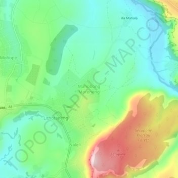
Name: Mahobong Moreneng topographic map, elevation, terrain.
Location: Mahobong Moreneng, Distrikt Leribe, Lesotho (-28.95187 28.15483 -28.91187 28.19483)
Average elevation: 1,688 m
Minimum elevation: 1,582 m
Maximum elevation: 1,900 m
Other topographic maps
Click on a map to view its topography, its elevation and its terrain.
Mohobollo
Lesotho > Distrikt Leribe > Litlhoatšaneng Ha-Lelahla
Mohobollo, Litlhoatšaneng Ha-Lelahla, Distrikt Leribe, Lesotho
Average elevation: 1,652 m