
New Zañiga topographic map
Interactive map
Click on the map to display elevation.
About this map
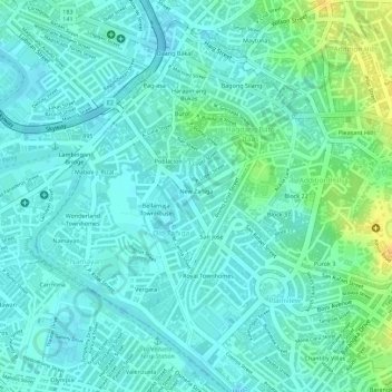
Name: New Zañiga topographic map, elevation, terrain.
Location: New Zañiga, Mandaluyong, Metro Manila, Philippines (14.58068 121.02724 14.58702 121.03198)
Average elevation: 11 m
Minimum elevation: 2 m
Maximum elevation: 31 m
Other topographic maps
Click on a map to view its topography, its elevation and its terrain.
Mandaluyong
Another claims that the Spaniards named the place based on the report of a navigator named Acapulco, who saw the rolling hills frequently being lashed at by daluyong (“big waves from the sea”). This seems to confirm traditional pre-Hispanic stories that giant waves from the sea would meet the adjoining…
Average elevation: 33 m