
Make a donation
Gear up for your next adventure:
As an Amazon Associate, this site earns from qualifying purchases at no extra cost to you.
Puy Jumel topographic map
Click on the map to display elevation.
Make a donation
Gear up for your next adventure:
As an Amazon Associate, this site earns from qualifying purchases at no extra cost to you.
About this map
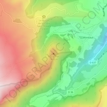
Name: Puy Jumel topographic map, elevation, terrain.
Average elevation: 1,276 m
Minimum elevation: 970 m
Maximum elevation: 1,624 m
Make a donation
Gear up for your next adventure:
As an Amazon Associate, this site earns from qualifying purchases at no extra cost to you.
Other topographic maps
Click on a map to view its topography, its elevation and its terrain.
Lac Chambon
France > Auvergne-Rhône-Alpes > Puy-de-Dôme > Chambon-sur-Lac > Lac Chambon
Average elevation: 952 m
63790
France > Auvergne-Rhône-Alpes > Puy-de-Dôme > Chambon-sur-Lac > Montaleix
Average elevation: 1,013 m
Plateau de Durbise
France > Auvergne-Rhône-Alpes > Puy-de-Dôme > Chambon-sur-Lac
Average elevation: 1,437 m
Vallée de Chaudefour
France > Auvergne-Rhône-Alpes > Puy-de-Dôme > Chambon-sur-Lac
Average elevation: 1,495 m
Make a donation
Gear up for your next adventure:
As an Amazon Associate, this site earns from qualifying purchases at no extra cost to you.
Réserve naturelle de la vallée de Chaudefour
France > Auvergne-Rhône-Alpes > Puy-de-Dôme > Chambon-sur-Lac
Average elevation: 1,419 m