
Tazacorte topographic map
Interactive map
Click on the map to display elevation.
About this map
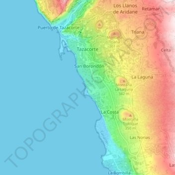
Name: Tazacorte topographic map, elevation, terrain.
Location: Tazacorte, Santa Cruz de Tenerife, Canarias, España (28.59201 -17.94970 28.66272 -17.90491)
Average elevation: 145 m
Minimum elevation: 0 m
Maximum elevation: 533 m
Other topographic maps
Click on a map to view its topography, its elevation and its terrain.
Montaña Todoque
España > Santa Cruz de Tenerife > Tazacorte
Montaña Todoque, Tazacorte, Santa Cruz de Tenerife, Canarias, 38769, España
Average elevation: 230 m