
Zion National Park topographic map
Interactive map
Click on the map to display elevation.
Zion National Park
The 8,726-foot (2,660 m) summit of Horse Ranch Mountain is the highest point in the park; the lowest point is the 3,666-foot (1,117 m) elevation of Coal Pits Wash, creating a relief of about 5,100 feet (1,600 m).
About this map
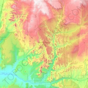
Name: Zion National Park topographic map, elevation, terrain.
Location: Zion National Park, Washington County, Utah, United States (37.14135 -113.22829 37.50429 -112.86315)
Average elevation: 1,877 m
Minimum elevation: 1,055 m
Maximum elevation: 2,876 m
Other topographic maps
Click on a map to view its topography, its elevation and its terrain.
Angels Landing
United States > Utah > Washington County
The trail to Angels Landing is 2.5 miles (4.0 km) long with an approximate 1,500 feet (460 m) elevation gain. The hike is rated as a class 3 difficulty based on the Yosemite Decimal System. It begins at the Grotto drop-off point on the park's shuttle system, which operates from early spring through late fall.…
Average elevation: 1,695 m
Virgin
United States > Utah > Washington County
Virgin is a town in Washington County, Utah, United States. The population was 596 at the 2010 census. The first settlement at Virgin was made in 1858. It is located along the Virgin River (for which it is named), and not far from Zion National Park. The elevation is 3,606 feet (1,099 m). It lies on State…
Average elevation: 1,251 m
Saint George
United States > Utah > Washington County
The St. George valley occasionally receives wet or slushy snowfall in the winter, but what accumulates usually melts off by the mid-to-late morning; the normal seasonal snowfall is 1.4 inches (3.6 cm). The earliest snowfall was measured on October 29, 1971, and the latest on April 11, 1927. The record…
Average elevation: 929 m
Cottonwood Canyon Wilderness
United States > Utah > Washington County > Washington
Average elevation: 1,213 m
Pine Valley Mountain Wilderness
United States > Utah > Washington County
Pine Valley Mountain Wilderness is a 50,232-acre (203.28 km2) wilderness area located in the Dixie National Forest in the U.S. state of Utah. It is the fourth-largest wilderness area located entirely within the state (following the High Uintas Wilderness, Zion Wilderness, and Cedar Mountain Wilderness). The…
Average elevation: 2,125 m