
Le Pieuré topographic map
Interactive map
Click on the map to display elevation.
About this map
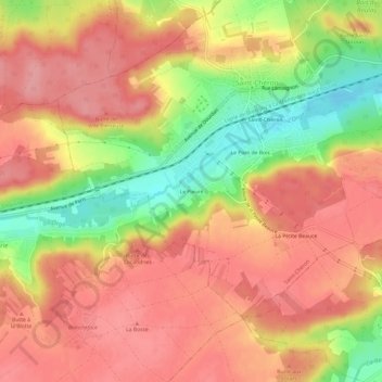
Name: Le Pieuré topographic map, elevation, terrain.
Average elevation: 127 m
Minimum elevation: 62 m
Maximum elevation: 163 m
Other topographic maps
Click on a map to view its topography, its elevation and its terrain.
Le Pont de Bois
France > Île-de-France > Essonne > Saint-Chéron
Le Pont de Bois, Saint-Chéron, Étampes, Essonne, Île-de-France, France métropolitaine, 91530, France
Average elevation: 120 m