
Bilbao topographic map
Interactive map
Click on the map to display elevation.
About this map
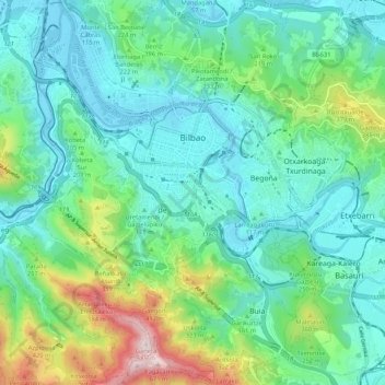
Name: Bilbao topographic map, elevation, terrain.
Average elevation: 156 m
Minimum elevation: -2 m
Maximum elevation: 674 m
Bilbao is located in the north-central part of Spain, some 16 kilometres (10 mi) south of the Bay of Biscay, where the economic social development is located, where the estuary of Bilbao is formed. Its main urban core is surrounded by two small mountain ranges with an average elevation of 400 metres (1,300 ft). Its climate is shaped by the Bay of Biscay low-pressure systems and mild air, moderating summer temperatures by Iberian standards, with low sunshine and high rainfall. The annual temperature range is low for its latitude.
Other topographic maps
Click on a map to view its topography, its elevation and its terrain.
Hondarribia
Spain > Autonomous Community of the Basque Country > Bidasoa Beherea / Bajo Bidasoa
Hondarribia, Bidasoa Beherea / Bajo Bidasoa, Gipuzkoa, Autonomous Community of the Basque Country, 20280, Spain
Average elevation: 37 m
San Sebastián
Spain > Autonomous Community of the Basque Country
San Sebastián, Gipuzkoa, Autonomous Community of the Basque Country, Spain
Average elevation: 120 m
Urretxu
Spain > Autonomous Community of the Basque Country
Urretxu, Gipuzkoa, Autonomous Community of the Basque Country, Spain
Average elevation: 460 m
Santa Barbara
Spain > Autonomous Community of the Basque Country > Hernani > Sorgintxulo
Santa Barbara, GI-2132, Portu, Sorgintxulo, Hernani, Gipuzkoa, Autonomous Community of the Basque Country, 20120, Spain
Average elevation: 68 m
Azpeitia
Spain > Autonomous Community of the Basque Country > Urola-Kosta
Azpeitia, Urola-Kosta, Gipuzkoa, Autonomous Community of the Basque Country, 20730, Spain
Average elevation: 395 m
Nanclares de la Oca/Langraiz Oka
Spain > Autonomous Community of the Basque Country > Añanako kuadrilla/Cuadrilla de Añana
Nanclares de la Oca/Langraiz Oka, Iruña Oka/Iruña de Oca, Añanako kuadrilla/Cuadrilla de Añana, Álava, Autonomous Community of the Basque Country, 01230, Spain
Average elevation: 613 m
Libiki
Spain > Autonomous Community of the Basque Country > Dima
Libiki, Dima, Biscay, Autonomous Community of the Basque Country, 48141, Spain
Average elevation: 188 m
Karakate
Spain > Autonomous Community of the Basque Country > Debabarrena > Soraluze
Karakate, Soraluze, Debabarrena, Gipuzkoa, Autonomous Community of the Basque Country, 20590, Spain
Average elevation: 366 m
Barakaldo
Spain > Autonomous Community of the Basque Country
Barakaldo, Biscay, Autonomous Community of the Basque Country, Spain
Average elevation: 127 m
Monterredondo
Spain > Autonomous Community of the Basque Country > Añanako kuadrilla/Cuadrilla de Añana
Monterredondo, Valdegovía/Gaubea, Añanako kuadrilla/Cuadrilla de Añana, Álava, Autonomous Community of the Basque Country, Spain
Average elevation: 875 m
Buruntza Auzoa
Spain > Autonomous Community of the Basque Country > Andoain
Buruntza Auzoa, Andoain, Gipuzkoa, Autonomous Community of the Basque Country, 20140, Spain
Average elevation: 143 m
Getxo
Spain > Autonomous Community of the Basque Country > Andraka
Getxo, Andraka, Biscay, Autonomous Community of the Basque Country, 48620, Spain
Average elevation: 36 m
Vitoria-Gasteiz
Spain > Autonomous Community of the Basque Country > Gasteizko kuadrilla/Cuadrilla de Vitoria
Vitoria-Gasteiz, Gasteizko kuadrilla/Cuadrilla de Vitoria, Álava, Autonomous Community of the Basque Country, Spain
Average elevation: 626 m
Ugao-Miraballes
Spain > Autonomous Community of the Basque Country
Ugao-Miraballes, Biscay, Autonomous Community of the Basque Country, 48490, Spain
Average elevation: 189 m
Mungia
Spain > Autonomous Community of the Basque Country > Andraka
Mungia, Andraka, Biscay, Autonomous Community of the Basque Country, 48620, Spain
Average elevation: 111 m
Errenteria
Spain > Autonomous Community of the Basque Country > Donostialdea
Errenteria, Donostialdea, Gipuzkoa, Autonomous Community of the Basque Country, 20100, Spain
Average elevation: 190 m
Oyón/Oion
Spain > Autonomous Community of the Basque Country > Arabako Errioxa/Rioja Alavesa
Oyón/Oion, Arabako Errioxa/Rioja Alavesa, Álava, Autonomous Community of the Basque Country, 01320, Spain
Average elevation: 572 m
Armiñón
Spain > Autonomous Community of the Basque Country > Añanako kuadrilla/Cuadrilla de Añana
Armiñón, Añanako kuadrilla/Cuadrilla de Añana, Álava, Autonomous Community of the Basque Country, 01220, Spain
Average elevation: 520 m
Eibar
Spain > Autonomous Community of the Basque Country > Debabarrena
Eibar, Debabarrena, Gipuzkoa, Autonomous Community of the Basque Country, 20600, Spain
Average elevation: 367 m
Ea
Spain > Autonomous Community of the Basque Country
Ea, Biscay, Autonomous Community of the Basque Country, 48287, Spain
Average elevation: 104 m
Plaza de Larrazábal
Spain > Autonomous Community of the Basque Country > Bilbao
Plaza de Larrazábal, Zurbaran-Arabella, Uribarri, Bilbao, Biscay, Autonomous Community of the Basque Country, Spain
Average elevation: 101 m
Ermua
Spain > Autonomous Community of the Basque Country
Ermua, Biscay, Autonomous Community of the Basque Country, 48260, Spain
Average elevation: 332 m
Irun
Spain > Autonomous Community of the Basque Country > Bidasoa Beherea / Bajo Bidasoa
Irun, Bidasoa Beherea / Bajo Bidasoa, Gipuzkoa, Autonomous Community of the Basque Country, Spain
Average elevation: 163 m
Dima
Spain > Autonomous Community of the Basque Country > Dima
Dima, Biscay, Autonomous Community of the Basque Country, 48141, Spain
Average elevation: 501 m
Zarautz
Spain > Autonomous Community of the Basque Country > Urola-Kosta > Zarautz
Zarautz, Urola-Kosta, Gipuzkoa, Autonomous Community of the Basque Country, 20800, Spain
Average elevation: 127 m
Zaldibar
Spain > Autonomous Community of the Basque Country > Zaldibar > Zaldibar
Zaldibar, Biscay, Autonomous Community of the Basque Country, 48250, Spain
Average elevation: 305 m
Oñati
Spain > Autonomous Community of the Basque Country > Debagoiena > Oñati
Oñati, Debagoiena, Gipuzkoa, Autonomous Community of the Basque Country, 20560, Spain
Average elevation: 488 m
Santurtzi
Spain > Autonomous Community of the Basque Country > Santurtzi
Santurtzi, Biscay, Autonomous Community of the Basque Country, 48980, Spain
Average elevation: 34 m
Gautegiz Arteaga
Spain > Autonomous Community of the Basque Country > Gautegiz Arteaga > Gautegiz Arteaga
Gautegiz Arteaga, Biscay, Autonomous Community of the Basque Country, 48314, Spain
Average elevation: 104 m
Portugalete
Spain > Autonomous Community of the Basque Country > Portugalete
Portugalete, Biscay, Autonomous Community of the Basque Country, 48920, Spain
Average elevation: 33 m
Maturana
Spain > Autonomous Community of the Basque Country > Arabako lautada/Llanada Alavesa
Maturana, Barrundia, Arabako lautada/Llanada Alavesa, Álava, Autonomous Community of the Basque Country, Spain
Average elevation: 562 m
Legazpi
Spain > Autonomous Community of the Basque Country
Legazpi, Gipuzkoa, Autonomous Community of the Basque Country, Spain
Average elevation: 548 m
Lekeitio
Spain > Autonomous Community of the Basque Country
Lekeitio, Biscay, Autonomous Community of the Basque Country, 48280, Spain
Average elevation: 60 m
Elgoibar
Spain > Autonomous Community of the Basque Country > Debabarrena > Elgoibar
Elgoibar, Debabarrena, Gipuzkoa, Autonomous Community of the Basque Country, Spain
Average elevation: 321 m
Biscay
Spain > Autonomous Community of the Basque Country
Biscay, Autonomous Community of the Basque Country, Spain
Average elevation: 333 m
Guernica
Spain > Autonomous Community of the Basque Country
Guernica, Biscay, Autonomous Community of the Basque Country, 48300, Spain
Average elevation: 68 m
Kortezubi
Spain > Autonomous Community of the Basque Country > Kortezubi
Kortezubi, Biscay, Autonomous Community of the Basque Country, 48315, Spain
Average elevation: 89 m
Somo
Spain > Autonomous Community of the Basque Country
Somo, Erriberagoitia/Ribera Alta, Añanako kuadrilla/Cuadrilla de Añana, Álava, Autonomous Community of the Basque Country, 01420, Spain
Average elevation: 768 m
Soil
Spain > Autonomous Community of the Basque Country > Montaña Alavesa/Arabako Mendialdea
Soil, Arraia-Maeztu, Montaña Alavesa/Arabako Mendialdea, Álava, Autonomous Community of the Basque Country, 01207, Spain
Average elevation: 898 m
Álava
Spain > Autonomous Community of the Basque Country
Álava, Autonomous Community of the Basque Country, Spain
Average elevation: 597 m
Elburgo/Burgelu
Spain > Autonomous Community of the Basque Country > Elburgo/Burgelu
Elburgo/Burgelu, Arabako lautada/Llanada Alavesa, Álava, Autonomous Community of the Basque Country, Spain
Average elevation: 616 m
Ibarra
Spain > Autonomous Community of the Basque Country > Tolosaldea
Ibarra, Tolosaldea, Gipuzkoa, Autonomous Community of the Basque Country, 20400, Spain
Average elevation: 259 m
Loiu
Spain > Autonomous Community of the Basque Country > Andraka
Loiu, Andraka, Biscay, Autonomous Community of the Basque Country, 48620, Spain
Average elevation: 70 m
Lalastra
Spain > Autonomous Community of the Basque Country > Añanako kuadrilla/Cuadrilla de Añana
Lalastra, Valderejo, Valdegovía/Gaubea, Añanako kuadrilla/Cuadrilla de Añana, Álava, Autonomous Community of the Basque Country, Spain
Average elevation: 947 m
Urduliz
Spain > Autonomous Community of the Basque Country > Andraka
Urduliz, Andraka, Biscay, Autonomous Community of the Basque Country, 48620, Spain
Average elevation: 90 m
Plentzia
Spain > Autonomous Community of the Basque Country > Andraka
Plentzia, Andraka, Biscay, Autonomous Community of the Basque Country, 48620, Spain
Average elevation: 61 m
Gipuzkoa
Spain > Autonomous Community of the Basque Country
Gipuzkoa, Autonomous Community of the Basque Country, Spain
Average elevation: 396 m