
Make a donation
Gear up for your next adventure:
As an Amazon Associate, this site earns from qualifying purchases at no extra cost to you.
Mount Gamkonora topographic map
Click on the map to display elevation.
Make a donation
Gear up for your next adventure:
As an Amazon Associate, this site earns from qualifying purchases at no extra cost to you.
Mount Gamkonora
Mount Gamkonora is a stratovolcano on Halmahera island, Indonesia. With an elevation of 1,560 metres (5,118 ft), it is the highest peak on the island. It has produced an elongated series of craters along the north–south rift.
Make a donation
Gear up for your next adventure:
As an Amazon Associate, this site earns from qualifying purchases at no extra cost to you.
About this map
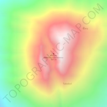
Name: Mount Gamkonora topographic map, elevation, terrain.
Average elevation: 1,113 m
Minimum elevation: 593 m
Maximum elevation: 1,549 m
Make a donation
Gear up for your next adventure:
As an Amazon Associate, this site earns from qualifying purchases at no extra cost to you.