
Make a donation
Gear up for your next adventure:
As an Amazon Associate, this site earns from qualifying purchases at no extra cost to you.
Arachova topographic map
Click on the map to display elevation.
Make a donation
Gear up for your next adventure:
As an Amazon Associate, this site earns from qualifying purchases at no extra cost to you.
Arachova
Arachova is situated at about a 970 m (3182 ft) elevation on the southern slope of Mount Parnassus, above the valley of the river Pleistos. The municipal unit has an area of 139.448 km2. Arachova is located 8 km E of Delphi, 9 km northwest of Distomo, 18 km southeast of Amfissa and 26 km west of Livadeia. The Greek National Road 48 (Naupactus - Delphi - Livadeia) passes through the town. The Parnassos Ski Centre is situated to the north.
Make a donation
Gear up for your next adventure:
As an Amazon Associate, this site earns from qualifying purchases at no extra cost to you.
About this map
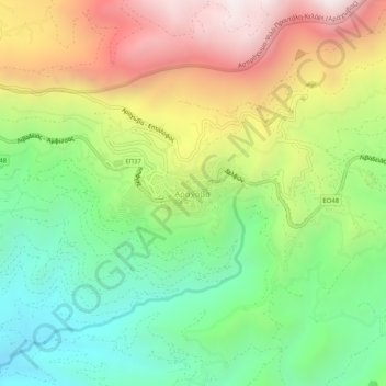
Name: Arachova topographic map, elevation, terrain.
Average elevation: 901 m
Minimum elevation: 310 m
Maximum elevation: 1,725 m
Make a donation
Gear up for your next adventure:
As an Amazon Associate, this site earns from qualifying purchases at no extra cost to you.