
Thank you for supporting this site ❤️
Make a donation
Make a donation
Gear up for your next adventure:
As an Amazon Associate, this site earns from qualifying purchases at no extra cost to you.
lohna topographic map
Click on the map to display elevation.
Thank you for supporting this site ❤️
Make a donation
Make a donation
Gear up for your next adventure:
As an Amazon Associate, this site earns from qualifying purchases at no extra cost to you.
About this map
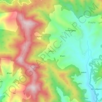
Name: lohna topographic map, elevation, terrain.
Location: lohna, Almora, Uttarakhand, 263637, India (29.71533 79.65918 29.75533 79.69918)
Average elevation: 1,653 m
Minimum elevation: 1,382 m
Maximum elevation: 1,981 m
Thank you for supporting this site ❤️
Make a donation
Make a donation
Gear up for your next adventure:
As an Amazon Associate, this site earns from qualifying purchases at no extra cost to you.