
Make a donation
Gear up for your next adventure:
As an Amazon Associate, this site earns from qualifying purchases at no extra cost to you.
Indre-et-Loire topographic map
Click on the map to display elevation.
Make a donation
Gear up for your next adventure:
As an Amazon Associate, this site earns from qualifying purchases at no extra cost to you.
About this map
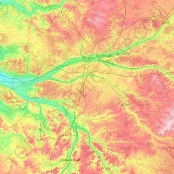
Name: Indre-et-Loire topographic map, elevation, terrain.
Location: Indre-et-Loire, Centre-Val de Loire, Metropolitan France, France (46.73666 0.05276 47.70979 1.36594)
Average elevation: 98 m
Minimum elevation: 24 m
Maximum elevation: 198 m
Make a donation
Gear up for your next adventure:
As an Amazon Associate, this site earns from qualifying purchases at no extra cost to you.
Other topographic maps
Click on a map to view its topography, its elevation and its terrain.
Terres du Gd Sous Les Vign
France > Centre-Val de Loire > Loiret > Dordives > Le Grand-sous-les-Vignes
Average elevation: 93 m
Make a donation
Gear up for your next adventure:
As an Amazon Associate, this site earns from qualifying purchases at no extra cost to you.
Make a donation
Gear up for your next adventure:
As an Amazon Associate, this site earns from qualifying purchases at no extra cost to you.
La Feuillarde
France > Centre-Val de Loire > Indre-et-Loire > Saint-Pierre-des-Corps
Average elevation: 55 m
Le Clos des Chênes
France > Centre-Val de Loire > Indre-et-Loire > Chouzé-sur-Loire
Average elevation: 30 m
Make a donation
Gear up for your next adventure:
As an Amazon Associate, this site earns from qualifying purchases at no extra cost to you.
La Diablerie
France > Centre-Val de Loire > Indre-et-Loire > Chanceaux-sur-Choisille
Average elevation: 111 m
La Porte, Château
France > Centre-Val de Loire > Loiret > Autruy-sur-Juine > La Porte
Average elevation: 121 m
Make a donation
Gear up for your next adventure:
As an Amazon Associate, this site earns from qualifying purchases at no extra cost to you.
Le Grand Village
France > Centre-Val de Loire > Indre-et-Loire > La Ville-aux-Dames
Average elevation: 51 m
Villarceaux
France > Centre-Val de Loire > Eure-et-Loir > Les Villages Vovéens
Average elevation: 151 m
Make a donation
Gear up for your next adventure:
As an Amazon Associate, this site earns from qualifying purchases at no extra cost to you.
²Le Grand Champ
France > Centre-Val de Loire > Indre > Lourouer-Saint-Laurent
Average elevation: 207 m
Make a donation
Gear up for your next adventure:
As an Amazon Associate, this site earns from qualifying purchases at no extra cost to you.
Plateau de Bel-Air
France > Centre-Val de Loire > Loir-et-Cher > Saint-Ouen > Côte de Bel-Air
Average elevation: 105 m
Rigaudon
France > Centre-Val de Loire > Loir-et-Cher > Montrichard Val de Cher
Average elevation: 97 m
Make a donation
Gear up for your next adventure:
As an Amazon Associate, this site earns from qualifying purchases at no extra cost to you.
Le Télégraphe
France > Centre-Val de Loire > Indre-et-Loire > Chambray-lès-Tours
Average elevation: 86 m
La Diablerie
France > Centre-Val de Loire > Indre-et-Loire > Chanceaux-sur-Choisille
Average elevation: 111 m
Pièce de la Fosse aux Joncs
France > Centre-Val de Loire > Indre > Saint-Maur
Average elevation: 161 m
Make a donation
Gear up for your next adventure:
As an Amazon Associate, this site earns from qualifying purchases at no extra cost to you.
Pièce du Bois et des Fosses
France > Centre-Val de Loire > Indre > Saint-Maur
Average elevation: 162 m
Make a donation
Gear up for your next adventure:
As an Amazon Associate, this site earns from qualifying purchases at no extra cost to you.
La Pente de l'Aigri
France > Centre-Val de Loire > Loir-et-Cher > Saint-Georges-sur-Cher
Average elevation: 99 m
Make a donation
Gear up for your next adventure:
As an Amazon Associate, this site earns from qualifying purchases at no extra cost to you.
Chartres Cathedral
France > Centre-Val de Loire > Eure-et-Loir > Chartres
The elevation of the nave, showing the gallery on the ground level; the narrow triforium; and, on top, the windows of the clerestory
Average elevation: 148 m
Make a donation
Gear up for your next adventure:
As an Amazon Associate, this site earns from qualifying purchases at no extra cost to you.
Make a donation
Gear up for your next adventure:
As an Amazon Associate, this site earns from qualifying purchases at no extra cost to you.
Chouzy
France > Centre-Val de Loire > Loir-et-Cher > La Chapelle-Saint-Martin-en-Plaine
Average elevation: 115 m
La Batardière
France > Centre-Val de Loire > Loir-et-Cher > Montrichard Val de Cher
Average elevation: 99 m
Make a donation
Gear up for your next adventure:
As an Amazon Associate, this site earns from qualifying purchases at no extra cost to you.
Domaine des Evis
France > Centre-Val de Loire > Eure-et-Loir > La Chapelle-Fortin
Average elevation: 220 m
La Bérangerie
France > Centre-Val de Loire > Indre-et-Loire > Saint-Jean-Saint-Germain
Average elevation: 108 m
Make a donation
Gear up for your next adventure:
As an Amazon Associate, this site earns from qualifying purchases at no extra cost to you.
Le Bois Turbet
France > Centre-Val de Loire > Indre-et-Loire > Marcé-sur-Esves
Average elevation: 82 m