
Thank you for supporting this site ❤️
Make a donation
Make a donation
Gear up for your next adventure:
As an Amazon Associate, this site earns from qualifying purchases at no extra cost to you.
Thiksey topographic map
Click on the map to display elevation.
Thank you for supporting this site ❤️
Make a donation
Make a donation
Gear up for your next adventure:
As an Amazon Associate, this site earns from qualifying purchases at no extra cost to you.
About this map
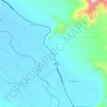
Name: Thiksey topographic map, elevation, terrain.
Location: Thiksey, Leh Tehsil, Leh district, Ladakh, 194201, India (34.03047 77.64864 34.07047 77.68864)
Average elevation: 3,304 m
Minimum elevation: 3,243 m
Maximum elevation: 3,743 m
Thank you for supporting this site ❤️
Make a donation
Make a donation
Gear up for your next adventure:
As an Amazon Associate, this site earns from qualifying purchases at no extra cost to you.