
Gemeinde Doren topographic map
Interactive map
Click on the map to display elevation.
About this map
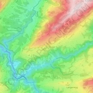
Name: Gemeinde Doren topographic map, elevation, terrain.
Location: Gemeinde Doren, Bezirk Bregenz, Vorarlberg, 6933, Österreich (47.47337 9.83790 47.51178 9.91988)
Average elevation: 666 m
Minimum elevation: 447 m
Maximum elevation: 1,017 m
Die Ortsmitte hat eine Höhe von 711 m ü. A., der tiefste Punkt ist die Rotachmündung mit 460 und der höchste Punkt die Haldenhöhe mit 960 m ü. A. Die Gemeinde hat eine Fläche von vierzehn Quadratkilometer. Davon ist fast die Hälfte landwirtschaftliche Nutzfläche, mehr als vierzig Prozent sind bewaldet.