
Make a donation
Gear up for your next adventure:
As an Amazon Associate, this site earns from qualifying purchases at no extra cost to you.
Penrhyn topographic map
Click on the map to display elevation.
Make a donation
Gear up for your next adventure:
As an Amazon Associate, this site earns from qualifying purchases at no extra cost to you.
Penrhyn
Penrhyn is a roughly circular coral atoll with a circumference of approximately 77 km (48 mi), enclosing a lagoon with an area of 233 square kilometres (90 sq mi). The atoll is atop the highest submarine volcano in the Cook Islands, rising 4,876 metres (15,997 ft) from the ocean floor. The atoll is low-lying, with a maximum elevation of less than 5 metres (16 ft). The total land area is 9.84 square kilometres (3.80 sq mi).
Make a donation
Gear up for your next adventure:
As an Amazon Associate, this site earns from qualifying purchases at no extra cost to you.
About this map
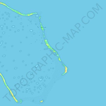
Name: Penrhyn topographic map, elevation, terrain.
Location: Penrhyn, Cook Islands (-9.08699 -158.05751 -8.91600 -157.87900)
Average elevation: 0 m
Minimum elevation: 0 m
Maximum elevation: 24 m
Make a donation
Gear up for your next adventure:
As an Amazon Associate, this site earns from qualifying purchases at no extra cost to you.
Other topographic maps
Click on a map to view its topography, its elevation and its terrain.