
Make a donation
Gear up for your next adventure:
As an Amazon Associate, this site earns from qualifying purchases at no extra cost to you.
Andoas topographic map
Click on the map to display elevation.
Make a donation
Gear up for your next adventure:
As an Amazon Associate, this site earns from qualifying purchases at no extra cost to you.
About this map
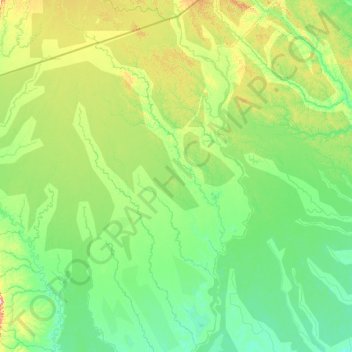
Name: Andoas topographic map, elevation, terrain.
Location: Andoas, Province of Datem del Marañón, Loreto, Peru (-4.23116 -77.22020 -2.51245 -76.20618)
Average elevation: 198 m
Minimum elevation: 131 m
Maximum elevation: 512 m
Make a donation
Gear up for your next adventure:
As an Amazon Associate, this site earns from qualifying purchases at no extra cost to you.
Other topographic maps
Click on a map to view its topography, its elevation and its terrain.
Make a donation
Gear up for your next adventure:
As an Amazon Associate, this site earns from qualifying purchases at no extra cost to you.
Daniel Alcides Carrion
Peru > Loreto > Vargas Guerra > Daniel Alcides Carrion
Average elevation: 123 m
Make a donation
Gear up for your next adventure:
As an Amazon Associate, this site earns from qualifying purchases at no extra cost to you.
Estrecho de Magallanes (Magallanes)
Peru > Loreto > Pebas > Estrecho de Magallanes (Magallanes)
Average elevation: 77 m