
Kootenay National Park topographic map
Interactive map
Click on the map to display elevation.
About this map
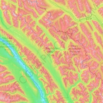
Name: Kootenay National Park topographic map, elevation, terrain.
Average elevation: 1,833 m
Minimum elevation: 785 m
Maximum elevation: 3,576 m
Kootenay National Park is a national park of Canada located in southeastern British Columbia. The park consists of 1,406 km2 (543 sq mi) of the Canadian Rockies, including parts of the Kootenay and Park mountain ranges, the Kootenay River and the entirety of the Vermilion River. While the Vermilion River is completely contained within the park, the Kootenay River has its headwaters just outside the park boundary, flowing through the park into the Rocky Mountain Trench and eventually joining the Columbia River. The park ranges in elevation from 918 m (3,012 ft) at the southwestern park entrance to 3,424 m (11,234 ft) at Deltaform Mountain.
Other topographic maps
Click on a map to view its topography, its elevation and its terrain.
Cascade Mountain
Canada > Alberta > Improvement District No. 9
Cascade Mountain, Improvement District No. 9, Alberta, T1L 1H8, Canada
Average elevation: 2,363 m
Saskatchewan Glacier
Canada > Alberta > Improvement District No. 9
Saskatchewan Glacier, Improvement District No. 9, Alberta, Canada
Average elevation: 2,255 m
Bow Glacier
Canada > Alberta > Improvement District No. 9
Bow Glacier, Improvement District No. 9, Alberta, Canada
Average elevation: 2,489 m
Kootenay National Park
Canada > Alberta > Improvement District No. 9
Kootenay National Park, Improvement District No. 9, Alberta, Canada
Average elevation: 1,833 m
Mount Assiniboine
Canada > Alberta > Improvement District No. 9
Mount Assiniboine, Improvement District No. 9, Alberta, Canada
Average elevation: 2,762 m
Peyto Glacier
Canada > Alberta > Improvement District No. 9
Peyto Glacier, Improvement District No. 9, Alberta, Canada
Average elevation: 2,421 m
Mount Forbes
Canada > Alberta > Improvement District No. 9
Mount Forbes, Improvement District No. 9, Alberta, Canada
Average elevation: 2,833 m