
Dolton topographic map
Click on the map to display elevation.
About this map
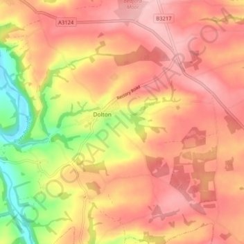
Name: Dolton topographic map, elevation, terrain.
Average elevation: 137 m
Minimum elevation: 42 m
Maximum elevation: 189 m
Devon trails, hiking, mountain biking, running and outdoor activities
Other topographic maps
Click on a map to view its topography, its elevation and its terrain.
Hartland Point
United Kingdom > England > Devon > Torridge District > Hartland
Average elevation: 20 m
Woollaton
United Kingdom > England > Devon > Torridge District > Peters Marland
Average elevation: 138 m