
Make a donation
Gear up for your next adventure:
As an Amazon Associate, this site earns from qualifying purchases at no extra cost to you.
Searchmont topographic map
Click on the map to display elevation.
Make a donation
Gear up for your next adventure:
As an Amazon Associate, this site earns from qualifying purchases at no extra cost to you.
About this map
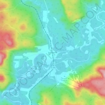
Name: Searchmont topographic map, elevation, terrain.
Average elevation: 261 m
Minimum elevation: 223 m
Maximum elevation: 421 m
Make a donation
Gear up for your next adventure:
As an Amazon Associate, this site earns from qualifying purchases at no extra cost to you.
Other topographic maps
Click on a map to view its topography, its elevation and its terrain.
St. Joseph Island
Canada > Ontario > Algoma District > Jocelyn Township
Its highest point, known colloquially and by surveyors as "the Mountain," is near the centre of the island near Carterton with an elevation of 345.6 m, which is about 169 m above Lake Huron.
Average elevation: 196 m
Make a donation
Gear up for your next adventure:
As an Amazon Associate, this site earns from qualifying purchases at no extra cost to you.
Make a donation
Gear up for your next adventure:
As an Amazon Associate, this site earns from qualifying purchases at no extra cost to you.