
Rupt-sur-Moselle topographic map
Interactive map
Click on the map to display elevation.
About this map
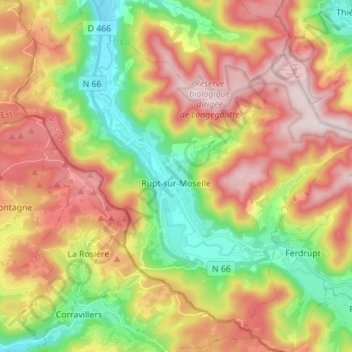
Name: Rupt-sur-Moselle topographic map, elevation, terrain.
Average elevation: 637 m
Minimum elevation: 400 m
Maximum elevation: 898 m
Other topographic maps
Click on a map to view its topography, its elevation and its terrain.
Le Chêne
France > Grand Est > Vosges > Rupt-sur-Moselle
Le Chêne, Rupt-sur-Moselle, Épinal, Vosges, Grand Est, Metropolitan France, 88360, France
Average elevation: 576 m