
Cranbrook topographic map
Interactive map
Click on the map to display elevation.
About this map
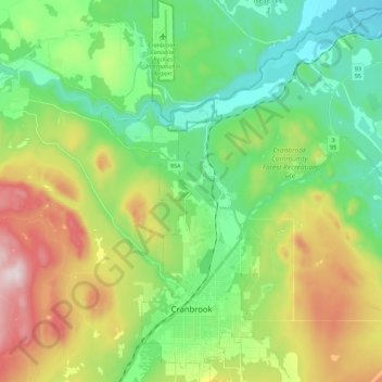
Name: Cranbrook topographic map, elevation, terrain.
Average elevation: 991 m
Minimum elevation: 764 m
Maximum elevation: 1,444 m
Other topographic maps
Click on a map to view its topography, its elevation and its terrain.
Area G (Forster Creek/Mount Assiniboine)
Canada > British Columbia > Regional District of East Kootenay
Area G (Forster Creek/Mount Assiniboine), Regional District of East Kootenay, British Columbia, Canada, Purcell Mountains
Average elevation: 2,710 m