
Immenstadt im Allgäu topographic map
Interactive map
Click on the map to display elevation.
About this map
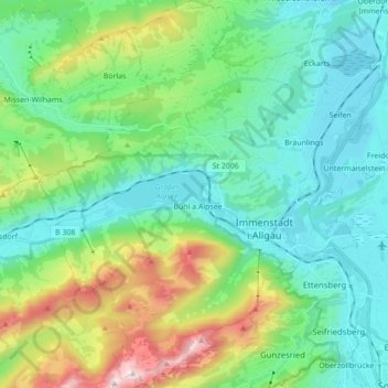
Name: Immenstadt im Allgäu topographic map, elevation, terrain.
Average elevation: 918 m
Minimum elevation: 697 m
Maximum elevation: 1,731 m
Other topographic maps
Click on a map to view its topography, its elevation and its terrain.
Nebelhorn
Germany > Bavaria > Landkreis Oberallgäu
Nebelhorn, Oberstdorf, Landkreis Oberallgäu, Bavaria, Germany
Average elevation: 1,792 m
Weitnau
Germany > Bavaria > Landkreis Oberallgäu
Weitnau, Weitnau (VGem), Landkreis Oberallgäu, Bavaria, 87480, Germany
Average elevation: 887 m
Wasach
Germany > Bavaria > Landkreis Oberallgäu > Oberstdorf > Tiefenbach
Wasach, Tiefenbach, Oberstdorf, Landkreis Oberallgäu, Bavaria, 87561, Germany
Average elevation: 904 m
Oberjoch
Germany > Bavaria > Landkreis Oberallgäu > Bad Hindelang
Oberjoch, Bad Hindelang, Landkreis Oberallgäu, Bavaria, 87541, Germany
Average elevation: 1,253 m
Polder
Germany > Bavaria > Landkreis Oberallgäu > Untermaiselstein
Polder, Untermaiselstein, Rettenberg, Landkreis Oberallgäu, Bavaria, 87549, Germany
Average elevation: 729 m
Oberstdorf
Germany > Bavaria > Landkreis Oberallgäu
Oberstdorf, Landkreis Oberallgäu, Bavaria, 87561, Germany
Average elevation: 1,490 m
Altusried
Germany > Bavaria > Landkreis Oberallgäu
Altusried, Landkreis Oberallgäu, Bavaria, 87452, Germany
Average elevation: 763 m