Geolocate

Grange topographic map

Click on the map to display elevation.

About this map

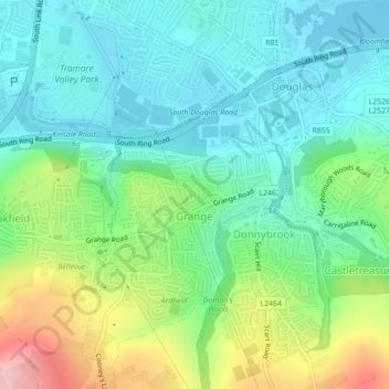
Name: Grange topographic map, elevation, terrain.

Location: Grange, Douglas, Cork, County Cork, Munster, Ireland (51.86293 -8.45018 51.87710 -8.43840)

Average elevation: 50 m

Minimum elevation: -3 m

Maximum elevation: 167 m

Other topographic maps

Click on a map to view its topography, its elevation and its terrain.

Cork

Ireland > County Cork > Cork

Average elevation: 94 m

Ballincollig

Ireland > County Cork > Cork

Average elevation: 62 m

Elizabeth Fort

Ireland > County Cork > Cork

Average elevation: 28 m

Gear up for your next adventure:

🐕Hiking Dog Harnesses - Rugged harnesses for taking your companion on mountain trails
🧼Camping Hygiene Kits - Compact hygiene essentials for outdoor stays
GPS Outdoor Watches - Watches with GPS tracking for hiking and exploration
🦟Anti-Midge & Tick Repellent - Vital for hiking in the Scottish Highlands during summer
🥫Expedition Meals - Lightweight, high-calorie nutrition for long-distance hikers

As an Amazon Associate, this site earns from qualifying purchases at no extra cost to you.