
Thank you for supporting this site ❤️
Make a donation
Make a donation
Gear up for your next adventure:
As an Amazon Associate, this site earns from qualifying purchases at no extra cost to you.
Deol topographic map
Click on the map to display elevation.
Thank you for supporting this site ❤️
Make a donation
Make a donation
Gear up for your next adventure:
As an Amazon Associate, this site earns from qualifying purchases at no extra cost to you.
About this map
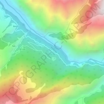
Name: Deol topographic map, elevation, terrain.
Location: Deol, Holi, Chamba, Himachal Pradesh, 176309, India (32.28459 76.56714 32.32459 76.60714)
Average elevation: 2,492 m
Minimum elevation: 1,791 m
Maximum elevation: 3,623 m
Thank you for supporting this site ❤️
Make a donation
Make a donation
Gear up for your next adventure:
As an Amazon Associate, this site earns from qualifying purchases at no extra cost to you.