
South Pond topographic map
Interactive map
Click on the map to display elevation.
About this map
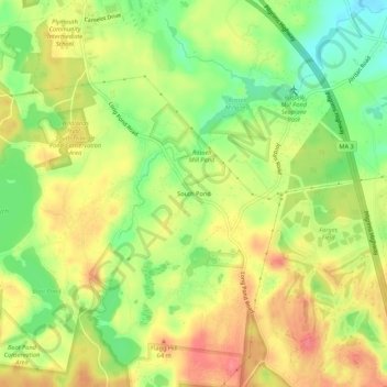
Name: South Pond topographic map, elevation, terrain.
Average elevation: 38 m
Minimum elevation: 1 m
Maximum elevation: 71 m
Other topographic maps
Click on a map to view its topography, its elevation and its terrain.
Great Herring Pond
United States > Massachusetts > Plymouth County > Plymouth > Cedarville
Average elevation: 24 m
Fresh Pond
United States > Massachusetts > Plymouth County > Plymouth > Cedar Bushes
Average elevation: 14 m