
Make a donation
Gear up for your next adventure:
As an Amazon Associate, this site earns from qualifying purchases at no extra cost to you.
Shediac topographic map
Click on the map to display elevation.
Make a donation
Gear up for your next adventure:
As an Amazon Associate, this site earns from qualifying purchases at no extra cost to you.
About this map
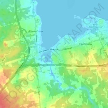
Name: Shediac topographic map, elevation, terrain.
Location: Shediac, Westmorland County, New Brunswick, Canada (46.20040 -64.58985 46.23254 -64.48950)
Average elevation: 17 m
Minimum elevation: -2 m
Maximum elevation: 57 m
Make a donation
Gear up for your next adventure:
As an Amazon Associate, this site earns from qualifying purchases at no extra cost to you.
Other topographic maps
Click on a map to view its topography, its elevation and its terrain.
Memramcook Lake
Canada > New Brunswick > Westmorland County > Dorchester Parish
Average elevation: 19 m
Make a donation
Gear up for your next adventure:
As an Amazon Associate, this site earns from qualifying purchases at no extra cost to you.
Make a donation
Gear up for your next adventure:
As an Amazon Associate, this site earns from qualifying purchases at no extra cost to you.
Haute-Aboujagane
Canada > New Brunswick > Westmorland County > Beaubassin East
Average elevation: 28 m