
Mull topographic map
Interactive map
Click on the map to display elevation.
About this map
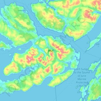
Name: Mull topographic map, elevation, terrain.
Location: Mull, Argyll and Bute, Scotland, United Kingdom (56.26284 -6.38584 56.65635 -5.64567)
Average elevation: 122 m
Minimum elevation: -2 m
Maximum elevation: 960 m
Other topographic maps
Click on a map to view its topography, its elevation and its terrain.
Loch Fyne
United Kingdom > Scotland > Argyll and Bute > Inveraray
Loch Fyne, Inveraray, Argyll and Bute, Scotland, PA32 8XT, United Kingdom
Average elevation: 137 m
Blairmore
United Kingdom > Scotland > Argyll and Bute
Blairmore, Argyll and Bute, Scotland, PA23 8TG, United Kingdom
Average elevation: 61 m
Beinn Dubh
United Kingdom > Scotland > Argyll and Bute
Beinn Dubh, Argyll and Bute, Scotland, United Kingdom
Average elevation: 470 m
Ben Cruachan
United Kingdom > Scotland > Argyll and Bute
Ben Cruachan, Argyll and Bute, Scotland, PA33 1AN, United Kingdom
Average elevation: 721 m
Bridge of Awe
United Kingdom > Scotland > Argyll and Bute
Bridge of Awe, Argyll and Bute, Scotland, PA35 1HT, United Kingdom
Average elevation: 237 m
Ford
United Kingdom > Scotland > Argyll and Bute
Ford, Argyll and Bute, Scotland, PA31 8RH, United Kingdom
Average elevation: 125 m
Lochgilphead
United Kingdom > Scotland > Argyll and Bute
Lochgilphead, Argyll and Bute, Scotland, PA31 8LZ, United Kingdom
Average elevation: 102 m
Machrimore
United Kingdom > Scotland > Argyll and Bute > Southend
Machrimore, Southend, Argyll and Bute, Scotland, PA28 6RP, United Kingdom
Average elevation: 38 m
Ardfin
United Kingdom > Scotland > Argyll and Bute
Ardfin, Argyll and Bute, Scotland, PA60 7XY, United Kingdom
Average elevation: 57 m
Portnahaven
United Kingdom > Scotland > Argyll and Bute
Portnahaven, Argyll and Bute, Scotland, PA47 7SL, United Kingdom
Average elevation: 13 m
Kilchoman
United Kingdom > Scotland > Argyll and Bute
Kilchoman, Argyll and Bute, Scotland, PA49 7UY, United Kingdom
Average elevation: 48 m
West Hynish
United Kingdom > Scotland > Argyll and Bute > Balephuil
West Hynish, Balephuil, Argyll and Bute, Scotland, PA77 6UF, United Kingdom
Average elevation: 14 m
Loch Long
United Kingdom > Scotland > Argyll and Bute > Ardentinny
Loch Long, Ardentinny, Argyll and Bute, Scotland, United Kingdom
Average elevation: 238 m
Glenfyne
United Kingdom > Scotland > Argyll and Bute
Glenfyne, Argyll and Bute, Scotland, PA26 8BJ, United Kingdom
Average elevation: 328 m
Leanach
United Kingdom > Scotland > Argyll and Bute
Leanach, Argyll and Bute, Scotland, PA27 8DB, United Kingdom
Average elevation: 131 m
Strone
United Kingdom > Scotland > Argyll and Bute
Strone, Argyll and Bute, Scotland, PA23 8RS, United Kingdom
Average elevation: 58 m
Cullipool
United Kingdom > Scotland > Argyll and Bute
Cullipool, Argyll and Bute, Scotland, PA34 4TX, United Kingdom
Average elevation: 12 m
Clachan
United Kingdom > Scotland > Argyll and Bute
Clachan, Argyll and Bute, Scotland, PA29 6YP, United Kingdom
Average elevation: 75 m
Toberonochy
United Kingdom > Scotland > Argyll and Bute
Toberonochy, Argyll and Bute, Scotland, PA34 4UF, United Kingdom
Average elevation: 15 m
Ascog
United Kingdom > Scotland > Argyll and Bute
Ascog, Argyll and Bute, Scotland, PA20 9EU, United Kingdom
Average elevation: 22 m
Scalasaig
United Kingdom > Scotland > Argyll and Bute
Scalasaig, Argyll and Bute, Scotland, PA61 7YT, United Kingdom
Average elevation: 30 m
Islay
United Kingdom > Scotland > Argyll and Bute
Islay, Argyll and Bute, Scotland, United Kingdom
Average elevation: 53 m
Port Askaig
United Kingdom > Scotland > Argyll and Bute
Port Askaig, Argyll and Bute, Scotland, PA46 7RD, United Kingdom
Average elevation: 45 m
Castle Lachlan
United Kingdom > Scotland > Argyll and Bute > Lephinmore
Castle Lachlan, B8000, Lephinmore, Argyll and Bute, Scotland, PA27 8BU, United Kingdom
Average elevation: 78 m
Saddell
United Kingdom > Scotland > Argyll and Bute
Saddell, Argyll and Bute, Scotland, PA28 6RA, United Kingdom
Average elevation: 89 m
Lochbuie
United Kingdom > Scotland > Argyll and Bute
Lochbuie, Argyll and Bute, Scotland, PA62 6AA, United Kingdom
Average elevation: 119 m
Minard Castle
United Kingdom > Scotland > Argyll and Bute > Minard > Tullochgorm
Minard Castle, A83, Tullochgorm, Minard, Argyll and Bute, Scotland, PA32 8YQ, United Kingdom
Average elevation: 34 m
Airds Bay
United Kingdom > Scotland > Argyll and Bute > Taynuilt
Airds Bay, Taynuilt, Argyll and Bute, Scotland, PA35 1JR, United Kingdom
Average elevation: 43 m
Oban
United Kingdom > Scotland > Argyll and Bute
Oban, Argyll and Bute, Scotland, PA34 5PZ, United Kingdom
Average elevation: 47 m
Loch Etive
United Kingdom > Scotland > Argyll and Bute > Connel
Loch Etive, Connel, Argyll and Bute, Scotland, United Kingdom
Average elevation: 318 m
Beinn Bhàn
United Kingdom > Scotland > Argyll and Bute
Beinn Bhàn, Argyll and Bute, Scotland, PA31 8RH, United Kingdom
Average elevation: 162 m
Rothesay Castle
United Kingdom > Scotland > Argyll and Bute > Rothesay
Rothesay Castle, Castlehill Street, Rothesay, Argyll and Bute, Scotland, PA20 0DA, United Kingdom
Average elevation: 42 m
Castle Sween
United Kingdom > Scotland > Argyll and Bute > Achnamara > Kilmichael of Inverlussa
Castle Sween, East Loch Sween Road, Kilmichael of Inverlussa, Achnamara, Argyll and Bute, Scotland, PA31 8PT, United Kingdom
Average elevation: 55 m
Cairnbaan
United Kingdom > Scotland > Argyll and Bute
Cairnbaan, Argyll and Bute, Scotland, PA31 8BA, United Kingdom
Average elevation: 68 m
Kames
United Kingdom > Scotland > Argyll and Bute
Kames, Argyll and Bute, Scotland, PA21 2AA, United Kingdom
Average elevation: 56 m
Ben More
United Kingdom > Scotland > Argyll and Bute
Ben More, Argyll and Bute, Scotland, PA70 6HQ, United Kingdom
Average elevation: 574 m
Ben Arthur (The Cobbler)
United Kingdom > Scotland > Argyll and Bute
Ben Arthur (The Cobbler), Argyll and Bute, Scotland, G83 7AS, United Kingdom
Average elevation: 504 m
Dunoon
United Kingdom > Scotland > Argyll and Bute
Dunoon, Argyll and Bute, Scotland, PA23 7HQ, United Kingdom
Average elevation: 99 m
Eilean Ramsay
United Kingdom > Scotland > Argyll and Bute > Port Ramsay
Eilean Ramsay, Port Ramsay, Argyll and Bute, Scotland, United Kingdom
Average elevation: 5 m
Strachur
United Kingdom > Scotland > Argyll and Bute
Strachur, Argyll and Bute, Scotland, PA27 8DG, United Kingdom
Average elevation: 125 m
Bridge of Orchy
United Kingdom > Scotland > Argyll and Bute
Bridge of Orchy, Argyll and Bute, Scotland, PA36 4AD, United Kingdom
Average elevation: 324 m
Tullochgorm
United Kingdom > Scotland > Argyll and Bute > Minard
Tullochgorm, Minard, Argyll and Bute, Scotland, PA32 8YQ, United Kingdom
Average elevation: 82 m
Ormsary
United Kingdom > Scotland > Argyll and Bute
Ormsary, Argyll and Bute, Scotland, PA31 8PE, United Kingdom
Average elevation: 70 m
Carradale
United Kingdom > Scotland > Argyll and Bute
Carradale, Argyll and Bute, Scotland, PA28 6SA, United Kingdom
Average elevation: 37 m
Succoth
United Kingdom > Scotland > Argyll and Bute
Succoth, Argyll and Bute, Scotland, G83 7BF, United Kingdom
Average elevation: 235 m
Loch Dochard
United Kingdom > Scotland > Argyll and Bute
Loch Dochard, Argyll and Bute, Scotland, United Kingdom
Average elevation: 318 m
Ardkinglas
United Kingdom > Scotland > Argyll and Bute > Cairndow
Ardkinglas, Cairndow, Argyll and Bute, Scotland, PA26 8BG, United Kingdom
Average elevation: 172 m
The Slate
United Kingdom > Scotland > Argyll and Bute
The Slate, Argyll and Bute, Scotland, PA28 6PZ, United Kingdom
Average elevation: 242 m
Helensburgh
United Kingdom > Scotland > Argyll and Bute
Helensburgh, Argyll and Bute, Scotland, G84 7NY, United Kingdom
Average elevation: 63 m
Tiree
United Kingdom > Scotland > Argyll and Bute > Balevullin
Tiree, Balevullin, Argyll and Bute, Scotland, United Kingdom
Average elevation: 3 m