
Columbia County topographic map
Interactive map
Click on the map to display elevation.
About this map
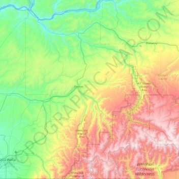
Name: Columbia County topographic map, elevation, terrain.
Location: Columbia County, Washington, USA (45.99889 -118.24264 46.62477 -117.60311)
Average elevation: 766 m
Minimum elevation: 161 m
Maximum elevation: 1,936 m
Other topographic maps
Click on a map to view its topography, its elevation and its terrain.
Long Beach
USA > Washington > Long Beach
Long Beach, Pacific County, Washington, 98631, USA
Average elevation: 5 m
North Cascades National Park
North Cascades National Park, Whatcom County, Washington, USA
Average elevation: 1,151 m
Marrowstone Island
Marrowstone Island, Marrowstone, Jefferson County, Washington, USA
Average elevation: 11 m
Olympic Mountains
Olympic Mountains, Jefferson County, Washington, 98305, USA
Average elevation: 511 m
Mount Rainier National Park
USA > Washington > Paradise
Mount Rainier National Park, Disappointment Cleaver Route, Paradise, Pierce County, Washington, USA
Average elevation: 1,411 m
Columbia Plateau
Columbia Plateau, Les Blair Road, Benton County, Washington, USA
Average elevation: 221 m
Cedardale
USA > Washington > Cedardale
Cedardale, Skagit County, Washington, 98238, USA
Average elevation: 32 m
Sunlight Beach
USA > Washington > Sunlight Beach
Sunlight Beach, Island County, Washington, USA
Average elevation: 18 m
Christmas Creek
Christmas Creek, Jefferson County, Washington, USA
Average elevation: 242 m
Maxwelton
USA > Washington > Maxwelton
Maxwelton, Island County, Washington, USA
Average elevation: 27 m
Hoquiam
USA > Washington > Hoquiam
Hoquiam, Grays Harbor County, Washington, 98550, USA
Average elevation: 29 m
Conrad Glacier
Conrad Glacier, Pacific Crest Trail, Yakima County, Washington, USA
Average elevation: 2,064 m
Middle Cascade Glacier
Middle Cascade Glacier, Ptarmigan Traverse, Chelan County, Washington, USA
Average elevation: 1,981 m
North Klawatti Glacier
North Klawatti Glacier, Lucky ridge boot trail, Skagit County, Washington, USA
Average elevation: 1,971 m
Port Hadlock-Irondale
USA > Washington > Port Hadlock-Irondale
Port Hadlock-Irondale, Jefferson County, Washington, USA
Average elevation: 55 m
Watcom County Railway and Electric Street Railway
USA > Washington > Bellingham
Watcom County Railway and Electric Street Railway, East North Street, Lettered Streets, Bellingham, Whatcom County, Washington, 98225-2698, USA
Average elevation: 37 m
South Cascade Glacier
South Cascade Glacier, Ptarmigan Traverse, Chelan County, Washington, USA
Average elevation: 1,972 m
West Nooksack Glacier
West Nooksack Glacier, Nooksack Cirque Trail, Whatcom County, Washington, USA
Average elevation: 1,443 m
Mary Green Glacier
USA > Washington > Holden Village
Mary Green Glacier, Cloudy Pass Trail #1256, Holden Village, Chelan County, Washington, USA
Average elevation: 2,140 m
Edmunds Glacier
Edmunds Glacier, Pierce County, Washington, USA
Average elevation: 2,619 m
Ptarmigan Glacier
Ptarmigan Glacier, Pacific Crest Trail, Snohomish County, Washington, USA
Average elevation: 2,025 m
Forbidden Glacier
Forbidden Glacier, Sahale Arm Trail, Skagit County, Washington, USA
Average elevation: 2,048 m
Lillian Glacier
Lillian Glacier, Cameron Pass Trail, Jefferson County, Washington, USA
Average elevation: 1,738 m
Sulphide Glacier
Sulphide Glacier, Sulfide Glacier Route, Whatcom County, Washington, USA
Average elevation: 1,815 m
Mount Seattle
Mount Seattle, Jefferson County, Washington, USA
Average elevation: 1,441 m
Hinman Glacier
Hinman Glacier, Necklace Valley Trail, King County, Washington, USA
Average elevation: 1,858 m
North Guardian Glacier
North Guardian Glacier, Pacific Crest Trail, Snohomish County, Washington, USA
Average elevation: 2,290 m
Butterfly Glacier
Butterfly Glacier, Chelan County, Washington, USA
Average elevation: 2,121 m
Van Trump Glacier
USA > Washington > Paradise
Van Trump Glacier, Van Trump Trail, Paradise, Pierce County, Washington, USA
Average elevation: 2,389 m
Mount Shuksan
Mount Shuksan, Whatcom County, Washington, USA
Average elevation: 2,126 m
Challenger Glacier
Challenger Glacier, Little Beaver Trail, Whatcom County, Washington, USA
Average elevation: 1,924 m
Rusk Glacier
Rusk Glacier, South Climb Trail #183, Yakima County, Washington, USA
Average elevation: 2,441 m
Jerry Glacier
USA > Washington > Anacortes Crossing
Jerry Glacier, Jackita Ridge Trail, Anacortes Crossing, Whatcom County, Washington, USA
Average elevation: 1,893 m
Whitman Glacier
Whitman Glacier, Wonderland Trail, Pierce County, Washington, USA
Average elevation: 2,519 m
Fremont Glacier
Fremont Glacier, Thunder Creek Trail, Skagit County, Washington, USA
Average elevation: 2,216 m
Flett Glacier
Flett Glacier, Spray Park Trail, Pierce County, Washington, USA
Average elevation: 2,185 m
Dark Glacier
Dark Glacier, Pacific Crest Trail, Chelan County, Washington, USA
Average elevation: 2,024 m
Fairchild Glacier
Fairchild Glacier, Mount Carrie Way Trail, Clallam County, Washington, USA
Average elevation: 1,611 m
White Glacier
White Glacier, Jefferson County, Washington, USA
Average elevation: 1,739 m
Katsuk Glacier
Katsuk Glacier, Fisher Creek Trail, Skagit County, Washington, USA
Average elevation: 2,007 m
Lynch Glacier
Lynch Glacier, Jade Lake Trail, King County, Washington, USA
Average elevation: 1,962 m
South Mowich Glacier
South Mowich Glacier, Emmons Glacier Route, Pierce County, Washington, USA
Average elevation: 3,307 m
White Salmon Glacier
White Salmon Glacier, Fisher Chimneys, Whatcom County, Washington, USA
Average elevation: 1,691 m
Lyman Glacier
Lyman Glacier, Highline Trail, Yakima County, Washington, USA
Average elevation: 2,722 m