
Thank you for supporting this site ❤️
Make a donation
Make a donation
Gear up for your next adventure:
As an Amazon Associate, this site earns from qualifying purchases at no extra cost to you.
Qamsar topographic map
Click on the map to display elevation.
Thank you for supporting this site ❤️
Make a donation
Make a donation
Gear up for your next adventure:
As an Amazon Associate, this site earns from qualifying purchases at no extra cost to you.
About this map
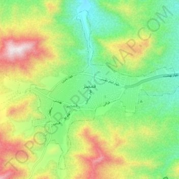
Name: Qamsar topographic map, elevation, terrain.
Location: Qamsar, Qamsar District, Kashan County, Isfahan Province, Iran (33.72441 51.40729 33.78039 51.48269)
Average elevation: 1,996 m
Minimum elevation: 1,659 m
Maximum elevation: 2,538 m
Thank you for supporting this site ❤️
Make a donation
Make a donation
Gear up for your next adventure:
As an Amazon Associate, this site earns from qualifying purchases at no extra cost to you.