Geolocate

Portmore topographic map

Click on the map to display elevation.

About this map

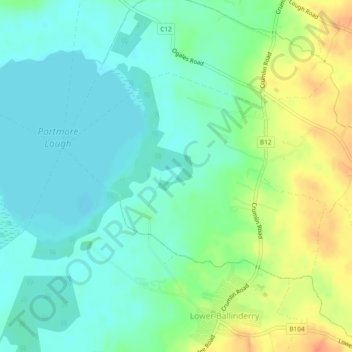
Name: Portmore topographic map, elevation, terrain.

Location: Portmore, Lower Ballinderry, Northern Ireland, United Kingdom (54.54735 -6.27779 54.56321 -6.24298)

Average elevation: 23 m

Minimum elevation: 8 m

Maximum elevation: 51 m

Northern Ireland trails, hiking, mountain biking, running and outdoor activities

Gear up for your next adventure:

🧺Ultralight Dry Bags - Organize and waterproof your gear inside your rucksack
📱Phone Mounts for Hiking - Secure mounts to carry your phone on trails
🔋Lithium AA Batteries - Long-lasting power that performs well in cold mountain weather
🎒Hiking Backpacks - Comfortable backpacks for day hikes and multi-day treks
📸Action Camera Chest Mounts - Record your ascent following topographic paths hands-free

As an Amazon Associate, this site earns from qualifying purchases at no extra cost to you.