
Make a donation
Gear up for your next adventure:
As an Amazon Associate, this site earns from qualifying purchases at no extra cost to you.
Drežanka topographic map
Click on the map to display elevation.
Make a donation
Gear up for your next adventure:
As an Amazon Associate, this site earns from qualifying purchases at no extra cost to you.
Drežanka
Drežanka springs at the foot of one of Bosnia and Herzegovina's largest mountain, Čvrsnica. Its karst spring rich in water is called Mošćenica or Mošćenuša and is situated at an altitude of 485 m. Not far downstream from the spring there are three waterfalls with a height of 10 to 12 meters.
Make a donation
Gear up for your next adventure:
As an Amazon Associate, this site earns from qualifying purchases at no extra cost to you.
About this map
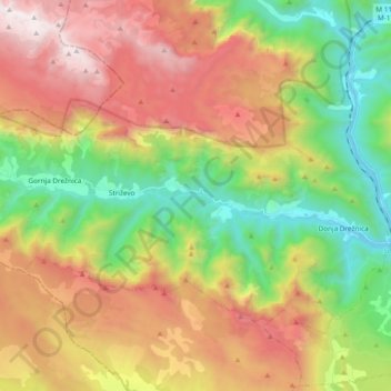
Name: Drežanka topographic map, elevation, terrain.
Average elevation: 1,038 m
Minimum elevation: 115 m
Maximum elevation: 2,217 m
Make a donation
Gear up for your next adventure:
As an Amazon Associate, this site earns from qualifying purchases at no extra cost to you.