Geolocate

Verona topographic map

Click on the map to display elevation.

About this map

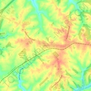
Name: Verona topographic map, elevation, terrain.

Location: Verona, Boone County, Kentucky, 41092, United States (38.79840 -84.68078 38.83840 -84.64078)

Average elevation: 259 m

Minimum elevation: 225 m

Maximum elevation: 283 m

Other topographic maps

Click on a map to view its topography, its elevation and its terrain.

Burlington

United States > Kentucky > Boone County

Average elevation: 250 m

Walton

United States > Kentucky > Boone County

Average elevation: 264 m

Walton

United States > Kentucky > Boone County

Average elevation: 264 m

Gear up for your next adventure:

🧊Insulated Flasks - Keeps drinks hot or cold during hikes
🔥Emergency Fire Starters - Reliable ignition tools for survival situations in damp conditions
🧷Tenacious Repair Tape - Instant fix for torn tents, jackets, or dry bags
🔪Outdoor Multi-Tools - Versatile tools for gear repairs and food prep in the wild
🕶️Polarized Sunglasses - Reduces glare from snow and water when reading terrain

As an Amazon Associate, this site earns from qualifying purchases at no extra cost to you.