Geolocate

Dalisodo topographic map

Click on the map to display elevation.

About this map
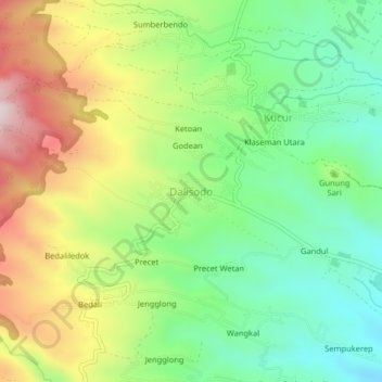
Name: Dalisodo topographic map, elevation, terrain.

Location: Dalisodo, Kabupaten Malang, East Java, Java, 65146, Indonesia (-7.99025 112.52270 -7.95025 112.56270)

Average elevation: 809 m

Minimum elevation: 573 m

Maximum elevation: 1,168 m

Other topographic maps

Click on a map to view its topography, its elevation and its terrain.
Pulau Sempu

Indonesia > East Java > Kabupaten Malang

Average elevation: 26 m

Pulau Sempu

Indonesia > East Java > Kabupaten Malang

Average elevation: 26 m

Tegalsari

Indonesia > East Java > Kabupaten Malang

Average elevation: 317 m

Gear up for your next adventure:

⛺Lightweight Solo Tents - Backpacking tents designed for wild camping in the UK highlands
🦟Anti-Midge & Tick Repellent - Vital for hiking in the Scottish Highlands during summer
🧷Tenacious Repair Tape - Instant fix for torn tents, jackets, or dry bags
🧗Locking Carabiners - Secure gear to your pack or for light technical use
🗺️Scratch-off Peak Maps - Track your progress climbing Munros or Wainwrights

As an Amazon Associate, this site earns from qualifying purchases at no extra cost to you.