
Holdenhurst topographic map
Click on the map to display elevation.
About this map
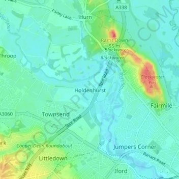
Name: Holdenhurst topographic map, elevation, terrain.
Average elevation: 12 m
Minimum elevation: -1 m
Maximum elevation: 54 m
Other topographic maps
Click on a map to view its topography, its elevation and its terrain.
Redhill Park
United Kingdom > England > Bournemouth, Christchurch and Poole > Bournemouth > Talbot Village
Average elevation: 33 m
Kings Park
United Kingdom > England > Bournemouth, Christchurch and Poole > Bournemouth
Average elevation: 31 m