
Arroyo Seco topographic map
Click on the map to display elevation.
Arroyo Seco
Arroyo Seco has a post office, with the ZIP code 87514. The 87514 ZIP Code Tabulation Area had a population of 1,310 at the 2000 census, with 996 housing units, a land area of 53.63 sq. miles, a water area of 0.05 sq. mile, and a population density of 24.43 people per sq. mile at Census 2000. Arroyo Seco's elevation is 7,634 feet.
About this map
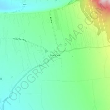
Name: Arroyo Seco topographic map, elevation, terrain.
Location: Arroyo Seco, Taos County, New Mexico, 87514, United States (36.49602 -105.58999 36.53602 -105.54999)
Average elevation: 2,338 m
Minimum elevation: 2,228 m
Maximum elevation: 2,623 m
Other topographic maps
Click on a map to view its topography, its elevation and its terrain.
Taos
United States > New Mexico > Taos County
The elevation of the town is 6,969 feet (2,124 m). Just north of Taos is Wheeler Peak, at 13,161 feet (4,011 m), the highest point in New Mexico. Taos has a warm-summer humid continental climate (Köppen Dfb), though it borders on a semi-arid climate (BSk) due to the low rainfall. The town is characterized by…
Average elevation: 2,180 m
Taos Ski Valley
United States > New Mexico > Taos County
Taos Ski Valley is a village and alpine ski resort in the southwestern United States, located in Taos County, New Mexico. The population was 69 at the 2010 census. Until March 19, 2008, it was one of four ski resorts in America to prohibit snowboarding. The Kachina lift, constructed in 2014, serves one of the…
Average elevation: 3,229 m
Taos
United States > New Mexico > Taos County
The elevation of the town is 6,969 feet (2,124 m). Just north of Taos is Wheeler Peak, at 13,161 feet (4,011 m), the highest point in New Mexico. Taos has a warm-summer humid continental climate (Köppen Dfb), though it borders on a semi-arid climate (BSk) due to the low rainfall. The town is characterized by…
Average elevation: 2,180 m