
Binh Ba Commune topographic map
Interactive map
Click on the map to display elevation.
About this map
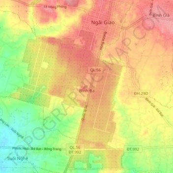
Name: Binh Ba Commune topographic map, elevation, terrain.
Average elevation: 90 m
Minimum elevation: 35 m
Maximum elevation: 132 m
Other topographic maps
Click on a map to view its topography, its elevation and its terrain.
Núi Nứa
Vietnam > Bà Rịa - Vũng Tàu Province > Chau Duc District > Xuan Son Commune
Average elevation: 78 m
Tân Thành
Vietnam > Bà Rịa - Vũng Tàu Province > Chau Duc District > Quang Thanh Commune
Average elevation: 135 m