
Thank you for supporting this site ❤️
Make a donation
Make a donation
Gear up for your next adventure:
As an Amazon Associate, this site earns from qualifying purchases at no extra cost to you.
Belen topographic map
Click on the map to display elevation.
Thank you for supporting this site ❤️
Make a donation
Make a donation
Gear up for your next adventure:
As an Amazon Associate, this site earns from qualifying purchases at no extra cost to you.
About this map
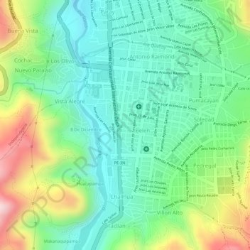
Name: Belen topographic map, elevation, terrain.
Location: Belen, Vista Alegre, Huaraz, Áncash, Perú, Parque Santa Rosa (-9.53238 -77.53156 -9.53159 -77.53119)
Average elevation: 3,111 m
Minimum elevation: 3,000 m
Maximum elevation: 3,317 m
Thank you for supporting this site ❤️
Make a donation
Make a donation
Gear up for your next adventure:
As an Amazon Associate, this site earns from qualifying purchases at no extra cost to you.