
Thank you for supporting this site ❤️
Make a donation
Make a donation
Gear up for your next adventure:
As an Amazon Associate, this site earns from qualifying purchases at no extra cost to you.
Trebiano topographic map
Click on the map to display elevation.
Thank you for supporting this site ❤️
Make a donation
Make a donation
Gear up for your next adventure:
As an Amazon Associate, this site earns from qualifying purchases at no extra cost to you.
About this map
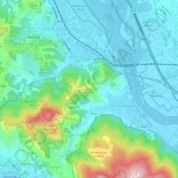
Name: Trebiano topographic map, elevation, terrain.
Location: Trebiano, Arcola, Follo, La Spezia, Liguria, 19021, Italia (44.08269 9.90329 44.12269 9.94329)
Average elevation: 77 m
Minimum elevation: -5 m
Maximum elevation: 346 m
Thank you for supporting this site ❤️
Make a donation
Make a donation
Gear up for your next adventure:
As an Amazon Associate, this site earns from qualifying purchases at no extra cost to you.
Other topographic maps
Click on a map to view its topography, its elevation and its terrain.
Montemarcello - Magra
Italia > Liguria > La Spezia > Arcola > Ponte di Arcola > Piano di Arcola
Average elevation: 26 m