
Miramas topographic map
Click on the map to display elevation.
About this map
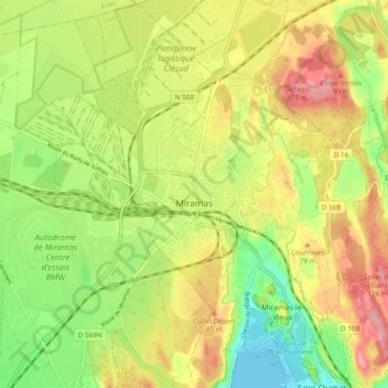
Name: Miramas topographic map, elevation, terrain.
Average elevation: 53 m
Minimum elevation: -2 m
Maximum elevation: 109 m
Other topographic maps
Click on a map to view its topography, its elevation and its terrain.
Plan de Campagne
France > Provence-Alpes-Côte d'Azur > Bouches-du-Rhône > Les Pennes-Mirabeau
Average elevation: 231 m
Giratoire du Mât de Ricca
France > Provence-Alpes-Côte d'Azur > Bouches-du-Rhône > Port-Saint-Louis-du-Rhône
Average elevation: 0 m
Aix-en-Provence
France > Provence-Alpes-Côte d'Azur > Bouches-du-Rhône > Aix-en-Provence
Average elevation: 279 m
Plan de Campagne
France > Provence-Alpes-Côte d'Azur > Bouches-du-Rhône > Les Pennes-Mirabeau
Average elevation: 231 m
Mont Saint-Cyr
France > Provence-Alpes-Côte d'Azur > Bouches-du-Rhône > Marseille
Average elevation: 382 m
Bassin du Vallon Dol
France > Provence-Alpes-Côte d'Azur > Bouches-du-Rhône > Marseille
Average elevation: 241 m
Barrage de Bimont
France > Provence-Alpes-Côte d'Azur > Bouches-du-Rhône > Saint-Marc-Jaumegarde
Average elevation: 354 m
Le Baguier
France > Provence-Alpes-Côte d'Azur > Bouches-du-Rhône > La Ciotat
Average elevation: 127 m
La Cride
France > Provence-Alpes-Côte d'Azur > Bouches-du-Rhône > Le Puy-Sainte-Réparade
Average elevation: 304 m