
Каменица topographic map
Interactive map
Click on the map to display elevation.
About this map
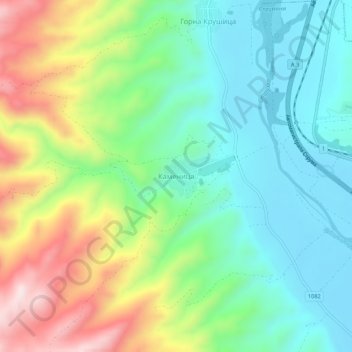
Name: Каменица topographic map, elevation, terrain.
Location: Каменица, Струмяни, Oblast Blagoewgrad, 2828, Bulgarien (41.63024 23.13998 41.67024 23.17998)
Average elevation: 278 m
Minimum elevation: 124 m
Maximum elevation: 581 m
Other topographic maps
Click on a map to view its topography, its elevation and its terrain.
Blagoewgrad
Bulgarien > Oblast Blagoewgrad
Blagoewgrad, Gemeinde Blagoewgrad, Oblast Blagoewgrad, 2700, Bulgarien
Average elevation: 831 m
Bansko
Bulgarien > Oblast Blagoewgrad
Bansko, Банско, Oblast Blagoewgrad, 2770, Bulgarien
Average elevation: 1,034 m