
Bandarban Hill District topographic map
Interactive map
Click on the map to display elevation.
About this map
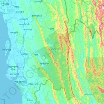
Name: Bandarban Hill District topographic map, elevation, terrain.
Location: Bandarban Hill District, Chittagong Division, Bangladesh (21.19983 92.06690 22.37488 92.68020)
Average elevation: 190 m
Minimum elevation: -2 m
Maximum elevation: 1,597 m
Other topographic maps
Click on a map to view its topography, its elevation and its terrain.
Chattogram
Bangladesh > Chittagong Division
Chittagong lies at 22°20′06″N 91°49′57″E / 22.33500°N 91.83250°E / 22.33500; 91.83250. It straddles the coastal foothills of the Chittagong Hill Tracts in southeastern Bangladesh. The Karnaphuli River runs along the southern banks of the city, including its central business district. The…
Average elevation: 6 m
Rangamati
Bangladesh > Chittagong Division > Rangamati Sadar Upazila
Rangamati (Bengali: রাঙ্গামাটি;) is the administrative headquarter and town of Rangamati Hill District in the Chittagong Hill Tracts of Bangladesh. The town is located at 22°37'60N 92°12'0E and has an altitude of 14 metres (46 ft).
Average elevation: 68 m