
Afgooye District topographic map
Interactive map
Click on the map to display elevation.
About this map
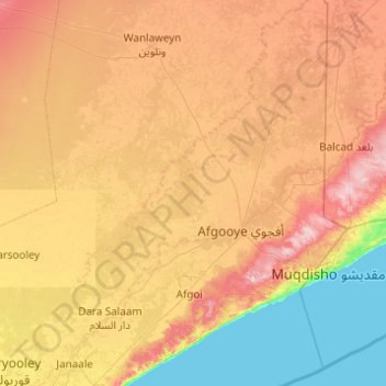
Name: Afgooye District topographic map, elevation, terrain.
Location: Afgooye District, Lower Shabelle, Somalia (1.74987 44.66000 2.73000 45.39000)
Average elevation: 76 m
Minimum elevation: 0 m
Maximum elevation: 181 m
Other topographic maps
Click on a map to view its topography, its elevation and its terrain.
Siinka Dheer
Somalia > Lower Shabelle > Afgooye District
Siinka Dheer, Afgooye District, Lower Shabelle, South West, Somalia
Average elevation: 133 m
Afgoi
Somalia > Lower Shabelle > Afgooye District
Afgoi, Afgooye District, Lower Shabelle, South West, Somalia
Average elevation: 86 m