
Legnica topographic map
Interactive map
Click on the map to display elevation.
About this map
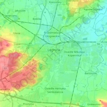
Name: Legnica topographic map, elevation, terrain.
Location: Legnica, Lower Silesian Voivodeship, Poland (51.16053 16.08325 51.24885 16.23321)
Average elevation: 128 m
Minimum elevation: 106 m
Maximum elevation: 180 m
Other topographic maps
Click on a map to view its topography, its elevation and its terrain.
Piątnica
Poland > Lower Silesian Voivodeship > Legnica
Piątnica, Legnica, Lower Silesian Voivodeship, Poland
Average elevation: 121 m