
Bagergue topographic map
Interactive map
Click on the map to display elevation.
About this map
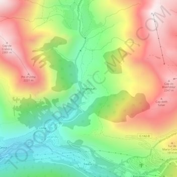
Name: Bagergue topographic map, elevation, terrain.
Location: Bagergue, Naut Aran, Val d'Aran, Lleida, Catalonia, 25539, Spain (42.69910 0.89619 42.73910 0.93619)
Average elevation: 1,714 m
Minimum elevation: 1,200 m
Maximum elevation: 2,327 m
Other topographic maps
Click on a map to view its topography, its elevation and its terrain.