Geolocate

West Elmira topographic map

Interactive map

Click on the map to display elevation.

About this map

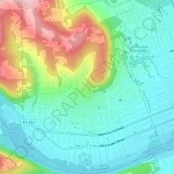
Name: West Elmira topographic map, elevation, terrain.

Location: West Elmira, Town of Elmira, Chemung County, New York, 14905, United States (42.07285 -76.86525 42.10566 -76.82620)

Average elevation: 320 m

Minimum elevation: 255 m

Maximum elevation: 467 m

Other topographic maps

Click on a map to view its topography, its elevation and its terrain.

Brand Park

United States > New York > Chemung County > City of Elmira

Brand Park, City of Elmira, Chemung County, New York, United States

Average elevation: 270 m

City of Elmira

United States > New York > Chemung County > City of Elmira

City of Elmira, Ashland, Chemung County, New York, United States

Average elevation: 296 m

Village of Millport

United States > New York > Chemung County

Village of Millport, Town of Veteran, Chemung County, New York, United States

Average elevation: 296 m

Langdon Hill

United States > New York > Chemung County

Langdon Hill, Chemung County, New York, 14838, United States

Average elevation: 449 m

Lowman

United States > New York > Chemung County

Lowman, Town of Ashland, Chemung County, New York, 14894, United States

Average elevation: 290 m

Village of Horseheads

United States > New York > Chemung County

Village of Horseheads, Town of Horseheads, Veteran, Chemung County, New York, 14845, United States

Average elevation: 298 m