
Make a donation
Gear up for your next adventure:
As an Amazon Associate, this site earns from qualifying purchases at no extra cost to you.
Zarqa topographic map
Click on the map to display elevation.
Make a donation
Gear up for your next adventure:
As an Amazon Associate, this site earns from qualifying purchases at no extra cost to you.
Zarqa
Zarqa has a cold semi-arid climate (Köppen climate classification: BSk). The average annual temperature is 17.4 °C (63.3 °F), and around 182 mm (7.17 in) of precipitation falls annually, mostly in winter months. Zarqa's elevation is 619 meters above sea level, and the city occasionally receives snowfall in winter.
Make a donation
Gear up for your next adventure:
As an Amazon Associate, this site earns from qualifying purchases at no extra cost to you.
About this map
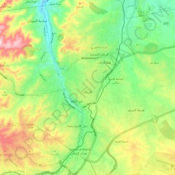
Name: Zarqa topographic map, elevation, terrain.
Location: Zarqa, Zarqa Sub-District, Zarqa Qasabah, Zarqa, Jordan (32.01972 36.01747 32.11856 36.13389)
Average elevation: 617 m
Minimum elevation: 491 m
Maximum elevation: 807 m
Make a donation
Gear up for your next adventure:
As an Amazon Associate, this site earns from qualifying purchases at no extra cost to you.
Other topographic maps
Click on a map to view its topography, its elevation and its terrain.