Geolocate

Stevenson topographic map

Click on the map to display elevation.

About this map

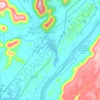
Name: Stevenson topographic map, elevation, terrain.

Location: Stevenson, Jackson County, Alabama, 35772, United States (34.76685 -85.90173 34.91647 -85.78587)

Average elevation: 242 m

Minimum elevation: 176 m

Maximum elevation: 495 m

Other topographic maps

Click on a map to view its topography, its elevation and its terrain.

Flat Rock

United States > Alabama > Jackson County

Average elevation: 422 m

Woodville

United States > Alabama > Jackson County

Average elevation: 212 m

Section

United States > Alabama > Jackson County

Average elevation: 349 m

Gear up for your next adventure:

🥾Hiking Boot Waterproofing Wax - Maintain the lifespan of your leather trekking boots
🧤Waterproof Overmitts - Extreme weather protection for hikers and mountaineers
🛌Sleeping Bags - Warm and packable sleeping bags for outdoor nights
🧴Sport Sunscreen Sticks - High-protection sunblock that won't run into your eyes on the trail
🧼Biodegradable Soap - Leave-no-trace hygiene for multi-day mountain treks

As an Amazon Associate, this site earns from qualifying purchases at no extra cost to you.