
Fushë Kosovë topographic map
Interactive map
Click on the map to display elevation.
Fushë Kosovë
Kosovo Polje is a municipality that lies in the center of the Kosovo Plain, with an area of 84 km2 (32 sq mi) and an altitude of 540 m (1,772 ft) above sea level. The city is situated between Pristina in the east, Obiliq in the north, Gračanica in the south and Drenas in the west. It consists of 16 settlements. It is located in the area of the intersection of roads important for transport, such as the railway connecting Kosovo Polje with Skopje and Mitrovica, which then connects to international roads. Also, it is located at the intersection of important highways. The Prishtina International Airport is also located on its territory.
About this map
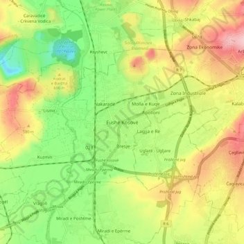
Name: Fushë Kosovë topographic map, elevation, terrain.
Average elevation: 558 m
Minimum elevation: 479 m
Maximum elevation: 650 m