
Alcácer do Sal topographic map
Interactive map
Click on the map to display elevation.
About this map
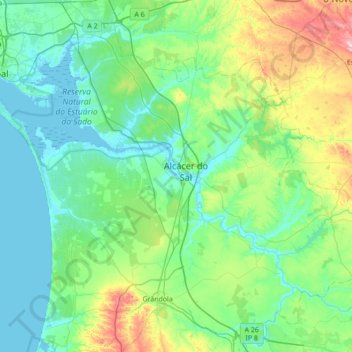
Name: Alcácer do Sal topographic map, elevation, terrain.
Location: Alcácer do Sal, Setúbal, Alentejo Litoral, Alentejo, Portugal (38.17840 -8.82276 38.55311 -8.12970)
Average elevation: 77 m
Minimum elevation: -3 m
Maximum elevation: 412 m
Other topographic maps
Click on a map to view its topography, its elevation and its terrain.
Alcaria Ruiva
Portugal > Alentejo > Mértola > Alcaria Ruiva
Alcaria Ruiva, Mértola, Alcaria Ruiva, Beja, Baixo Alentejo, Alentejo, Portugal
Average elevation: 195 m
Portalegre
Portugal > Alentejo > Portalegre
Portalegre, Alto Alentejo, Alentejo, 7300-139, Portugal
Average elevation: 416 m
Caneja
Portugal > Alentejo > Boavista dos Pinheiros
Caneja, Boavista dos Pinheiros, Odemira, Beja, Alentejo Litoral, Alentejo, 7630-171, Portugal
Average elevation: 35 m