Syke topographic map
Interactive map
Click on the map to display elevation.
About this map
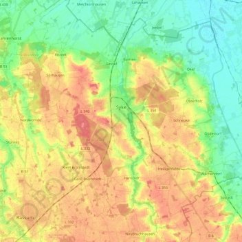
Name: Syke topographic map, elevation, terrain.
Location: Syke, Landkreis Diepholz, Lower Saxony, 28857, Germany (52.83537 8.73140 52.97431 8.95208)
Average elevation: 33 m
Minimum elevation: 5 m
Maximum elevation: 64 m
Other topographic maps
Click on a map to view its topography, its elevation and its terrain.
Barnstorf
Germany > Lower Saxony > Landkreis Diepholz
Barnstorf, Samtgemeinde Barnstorf, Landkreis Diepholz, Lower Saxony, Germany
Average elevation: 38 m
Sulingen
Germany > Lower Saxony > Landkreis Diepholz
Sulingen, Landkreis Diepholz, Lower Saxony, 27232, Germany
Average elevation: 44 m
Drebber
Germany > Lower Saxony > Landkreis Diepholz > Drebber
Drebber, Samtgemeinde Barnstorf, Landkreis Diepholz, Lower Saxony, 49457, Germany
Average elevation: 38 m
Brockum
Germany > Lower Saxony > Landkreis Diepholz
Brockum, Samtgemeinde Altes Amt Lemförde, Landkreis Diepholz, Lower Saxony, Germany
Average elevation: 47 m